

You are here
Sponsored by:
Climbing
Snow/glacier/ice route
Elevation Gain
2,500.00 ft (762.00 m)
Distance
8.80 mi (14.16 km)
Please respect the outdoors by practicing Leave No Trace. Learn more about how to apply the principles of Leave No Trace on your next outdoor adventure here.
Only fully discovered and documented in 2011, Mount Hood's Sandy Glacier is home to the largest and most extensive glacier cave system in the contiguous United States.
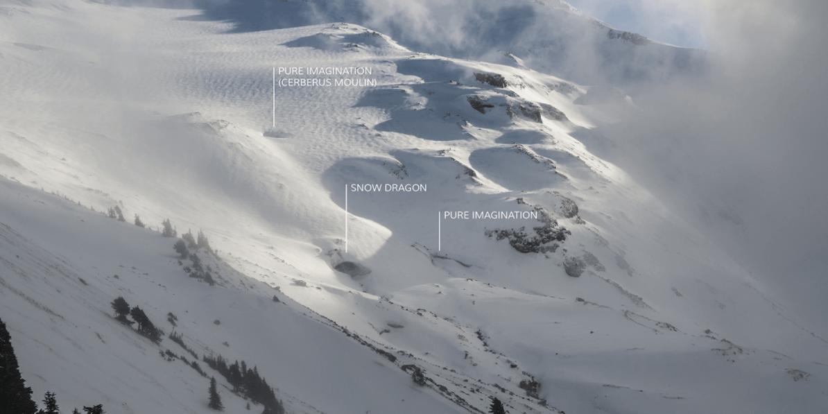
The caves begin a mile uphill from McNeil Point, where erosion from the rapidly-retreating glacier on Mount Hood's western face has created a combined 7,000 linear feet of caverns, caves and narrow passages. Known today as the Sandy Glacier Caves, this extensive network is comprised of three main caves: Snow Dragon, which has recently experienced a collapse, Pure Imagination, and Frozen Minotaur.
Though initial cave sightings were reported as early as 2000, their existence was only officially confirmed via a YouTube video by Gregory Fowler in 2010. Based on the video, mountaineers, cavers, and close friends Eddy Cartaya and Brent McGregor enlisted help from friends and several local mountain rescue teams and embarked on a series of painstaking expeditions to fully map and document the cave...one that they would later name Snow Dragon. While on the expedition in 2011, they further discovered Pure Imagination and Frozen Minotaur.
The Science

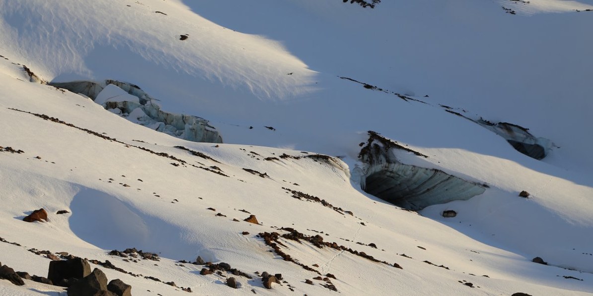
Mount Hood's Sandy Glacier Caves in January of 2014. Photo by Tyson Gillard.
Scientists have documented the recent and widespread retreat of glaciers due to climate change for a number of years. Using surface-scanning technologies such as lidar, scientists can fairly easily track the changing volume of glaciers. Tracking this change from inside the glacier is a new approach, however, and teams like Cartaya and McGregor's and photographers like Eric Guth hope to better understand this interior deterioration and to share this information with the world.
Glaciologists have found that large glacial caves such as these only occur in thin, dying glaciers, whereas caves that form in larger and thicker glaciers quickly collapse under their own weight. Because the peaks of the Cascade Range lie in relatively warm climates (as opposed to Alaska, for instance), surface friction alone is often enough to introduce some melting. Once a channel of water is formed, its size will only increase over time as more water passes through. Additionally, the caves allow warm air to enter deep into the glacier, ensuring an even quicker melting process.

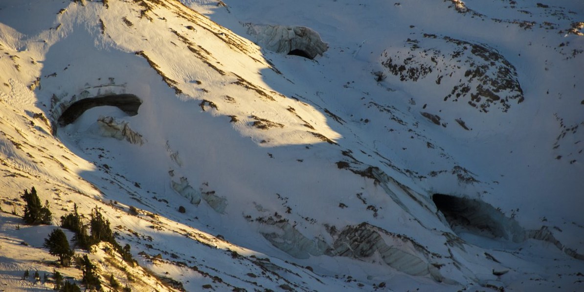
The Sandy Glacier Caves in January of 2015, notice the collapse of Snow Dragon. Photo by Shane Kucera.

The caves seen from McNeil Point in November of 2015. Photo by Andrew Stohner.
The process is not without precedent: The Paradise Glacier Caves on Mount Rainier's south side were once a major attraction to the national park. By the 1970s, however, the ceiling began to collapse. Today, the caves are long gone, and the lower portion of the glacier no longer exists.
Safety + Getting There
From the McNeil Point Shelter, it is a long and exposed off-trail traverse to the cave entrances at roughly 6,500 feet. In late summer, the field of steep talus is only intermittently held together by ground juniper, pink mountain heather, and the occasional mountain hemlock or whitebark pine. The spring and summer seasons are also when the majority of melting occurs and when the caves pose the greatest danger, as large boulders constantly drop from the ceiling and sheets of ice break away from the entrances. SPRING AND SUMMER TRAVEL IS NOT ADVISED.
Relatively speaking, winter is the safest time to be inside the caves, although falling debris is still common. The off-trail traverse from the McNeil Point Shelter is steep and requires crampons and ice axes at the minimum. Adventurers should give themselves at least 7 hours to reach the caves from the Top Spur Trailhead. NF-1828, which leads to the Top Spur Trailhead, is not maintained during the winter months, however. If you are unable to reach the Top Spur Trailhead due to snowpack, you may have to park 7.8 miles further down the road at at Muddy Fork Road.
Nearby Adventures


Nearby Lodging + Camping


Brought to you by:
Oregon Field Guide is OPB's long-running local weekly TV series. The program covers natural resources, ecological issues, outdoor recreation and travel destinations across the Northwest region. This award-winning show is one of the most-watched local productions in the public broadcasting system.
Oregon Field Guide also extends the work it does in the field for the television series across radio and the Web, providing a greater degree of coverage.
Oregon Field Guide airs Thursday evenings at 8:30 p.m. and repeats Sundays at 1:30 a.m. and 6:30 p.m. In the Mountain Time zone of Eastern Oregon, the program airs at 9:30 p.m. Thursdays, and at 7:30 p.m. Sundays.
More content from Oregon Field Guide


 Falls Hike")
Comments
Of note: time from Top Spur Trailhead to the caves was a little less than 4 hours total (with a semi-leisurely pace and breaks for snacks and photos). The 7 hour time suggestion in this post may be dependent on conditions, but seems severe. I'd suggest 3.5-4.5 hours is more likely, depending on trail and snow conditions.
As suggested in every post so far-- be careful when entering the caves! Rock and ice fall are likely... you don't want to be the person in the caves when they collapse.
Sign In and share them.