On January 24, 1952, a CIA flight training mission in an SA-16 Albatross with 6 people on board flying from Idaho to San Diego began experiencing a loss of power in one of its two engines. Hovering somewhere over Death Valley, the plane began to experience a loss of speed and altitude. The pilot gave the order to evacuate, and all six onboard donned emergency parachutes and jumped into the night sky. Each of the six would land without injury, though the Albatross would strike a high stone mountain near Towne Peak, its wreckage lodging itself into the gravel immediately below, where it would come to rest precariously tilted above the sheer drop below.
The classified material from the plane was collected soon after, though the wreck itself was deemed too remote for removal and was abandoned.
It remains possible to hike to the wreck site; however, there are several reasons why this hike is only attempted by few.
The 10-mile out-and-back requires hikers to climb a cockscomb circuit of peaks en route. While there is about 2,300 feet of net elevation gain between the parking area and the trek's highest point at Towne Peak (7,269 feet), there are several descents between peaks, and over 1,000 feet of elevation loss from Towne Peak to the wreck site. This adds up to a hike totaling about 4,000 feet of total elevation gain over its total length.
Additionally, Death Valley has both brutal summers and unforgiving cold conditions at the high elevations during the winters. There is no shade or shelter along this hike, and the route - already filled with soft dirt and volcanic boulders - may be buried beneath snow during the cold season. This means that for planning purposes, there are only a few months a year in the transitional seasons where conditions may be ideal for this hike.
And finally, there is no trail. Other than a few geological survey markers on the peaks and two cache boxes, there is nothing marking the route. Hikers will have to scale the boulder-filled slopes and circumnavigate their way around the series of peaks on their own route. And while the way to Towne Pass and the wreck site becomes clear once you reach the first peak, 1,000 feet above the parking area, it forces you to pay attention to your steps and focus much more than a simple physical hike may require.
This hike is strenuous, and it should only be attempted by fit hikers carrying appropriate supplies such as extra water and headlamps, beginning early in the day. A very fit hiker who makes minimal stops along the hike can count on an eight hour effort to finish the hike. Others have reported finishing the hike in about 11 hours.
From the parking area, proceed north up the stone and brush-covered slope, climbing about 1,000 feet in elevation. From the first peak you can use binoculars and look across to the north to see the plane wreck below the mountaintops. Keep an eye on this site as you hike because this will be your reference for where you're trying to end up. Continue to the right as you climb a series of taller and taller peaks before summiting Towne Peak and beginning the descent on the other side. Regardless of the weather, these high peaks can have extremely strong winds with no shelter or wind protection of any kind.
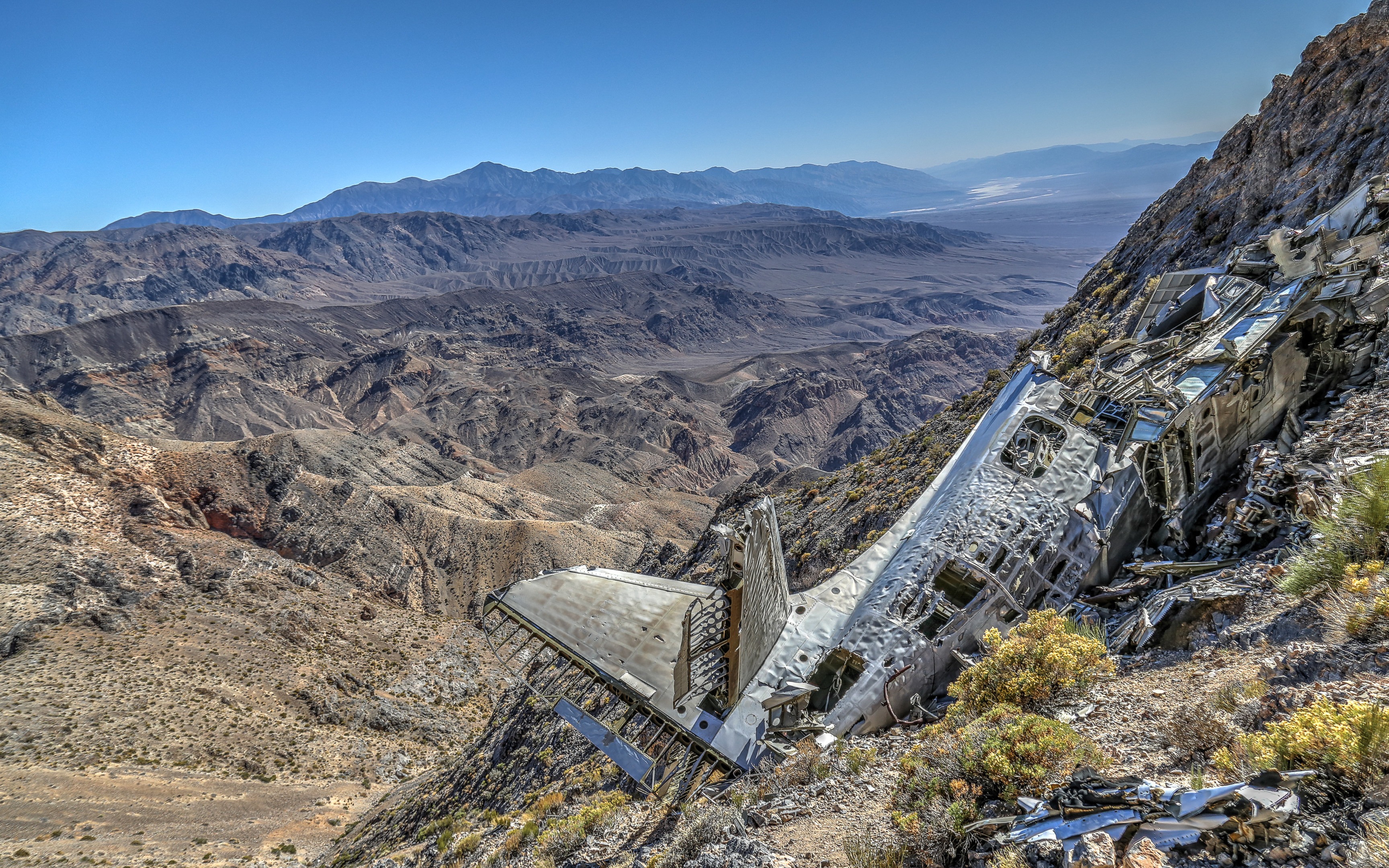
From a second cache box located in a saddle at about 4.8 miles, veer left sharply to begin a steep descent down a 200-foot loose gravel slope to the Albatross wreck. The plane remains in surprisingly good condition, though wind, storms and gravity have carried many of its pieces into the distant chasm far below. Wind whistles through the wrecked twisted aluminum, as it is possible to carefully circle the main fuselage and see many of its parts there on the mountainside. It's surreal to imagine the plane descending into the remote mountains in the dead of night, overlooking the Panamint Valley in the distance.
Keep in mind that early afternoon shadows engulf the wreck's location on the cliffside. Return the route you came, giving yourself enough time to get back to the parking area before dark settles over the boulder-strewn slopes.
There are no amenities of any kind at the parking area and along the trail. Food and water is available at Panamint Springs to the west or at Stovepipe Wells to the east. This is a hard, strenuous hike, with no shade, wind protection or cell service and in potentially harsh Death Valley conditions. Be prepared.


Comments
Sign In and share them.