Pets allowed
Allowed
Elevation Gain
312.00 ft (95.10 m)
Trail type
There-and-back
Distance
3.60 mi (5.79 km)
Please respect the outdoors by practicing Leave No Trace. Learn more about how to apply the principles of Leave No Trace on your next outdoor adventure here.

With close proximity to Proxy Falls, Linton Lake might be easily overlooked, but if you find yourself in the area, it's definitely worth the short hike out to the lake. With beautiful views, old-growth forests, and ancient lava flows, the hike has many interesting sights and is great on a hot summer or fall day. As the trailhead sign suggests, "Savor the solitude. Embrace this opportunity for self-discovery and primitive recreation."

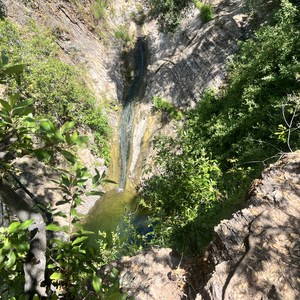
The there-and-back trail starts across the road from the Alder Springs Campground and wanders through old-growth forests and old lava flows. The main trail ends where Obsidian Creek flows into the lake, but there are many unmaintained trails around the surrounding area. Be careful when exploring around the lava flows as the rocks can be unstable and easily shift underfoot. There is a waterfall upstream, but it is not visible from the lake. 

Backcountry campsites can be found around the lake and make for a nice overnight trip in the Three Sisters Wilderness. Sites include fire rings.

Highway 242 leading to the trailhead is closed November through June. Parking at the trailhead is limited.

Logistics + Planning

Preferable season(s)

Spring
Summer
Fall

Congestion

Moderate

Parking Pass

NW Forest Pass

Pros

Great views.

Cons

No clear trail around the lake or to the waterfall.

Trailhead Elevation

3,467.00 ft (1,056.74 m)

Features

Backcountry camping
Waterfalls
Bird watching
Wildlife
Big vistas
Old-growth forest
Wildflowers
Geologically significant

Location

Comments

06/17/2016
Took the time to check this out while in the area. Great quick trail and would be fun to camp at verse staying next to the road at Alder Springs. It should be noted that ODOT usually has the road open to the snow gate at Alder Springs in the early spring which makes this hike accessible earlier in the year. Check with the ranger station at the base of the pass in McKenzie Bridge to see how much of the road is open prior to heading out.
Have updates, photos, alerts, or just want to leave a comment?
Sign In and share them.