Grand Staircase-Escalante National Monument contains 1.9 million acres of pristine desert. It is often overshadowed by Utah's five national parks, but don't be fooled; this area of desert is perhaps the most stunning desert landscape in the entire state. This place is wild and vast. Trails are typically unmaintained footpaths that follow streams and canyons. Grand Staircase-Escalante National Monument is part of a larger ecosystem that is perhaps the wildest landscape in the Lower 48. With Bryce Canyon National Park to the west, the San Rafael Swell and Capitol Reef to the east, Lake Powell to the south, and the Escalante Mountains to the north, this area is surrounded by wilderness. It is a place for hardy explorers who appreciate route finding and solitude. Simply put, there are few places in the Lower 48 that have the exploration opportunities that exist in the Escalante area.
Death Hollow is a stunning canyon that empties into the Escalante River just north of town in the northern section of the monument. Death Hollow and the surrounding landscape is actually located within the Box-Death Hollow Wilderness, so all wilderness rules apply. While day hikers could perhaps explore the bottom reaches of the canyon via hiking the Escalante River, the only way to see the majority of the canyon is to backpack it, which would typically take three days.
Backpacking this loop combines three different trails, all of which have their own difficulties. The Boulder Mail Trail, which runs from the town of Escalante to Boulder, is the first trail featured on this loop. Finding the actual start of the trail can be difficult, so make sure to have a map and a GPS. Start at the Escalante River Trailhead just outside the town of Escalante. Follow the trail for about 1.5 miles until there is a small tributary on the left. Walk up this tributary to reach the start of the climb up the Boulder Mail Trail. The Boulder Mail Trail is stunning. Once on the plateau, this trail traverses big desert meadows and expansive reaches of slickrock. It is remote, and the views are huge. The trail goes about 8 miles until it descends into Death Hollow, but Mamie Creek, which lies at mile 6, is a great place to camp on the first day.
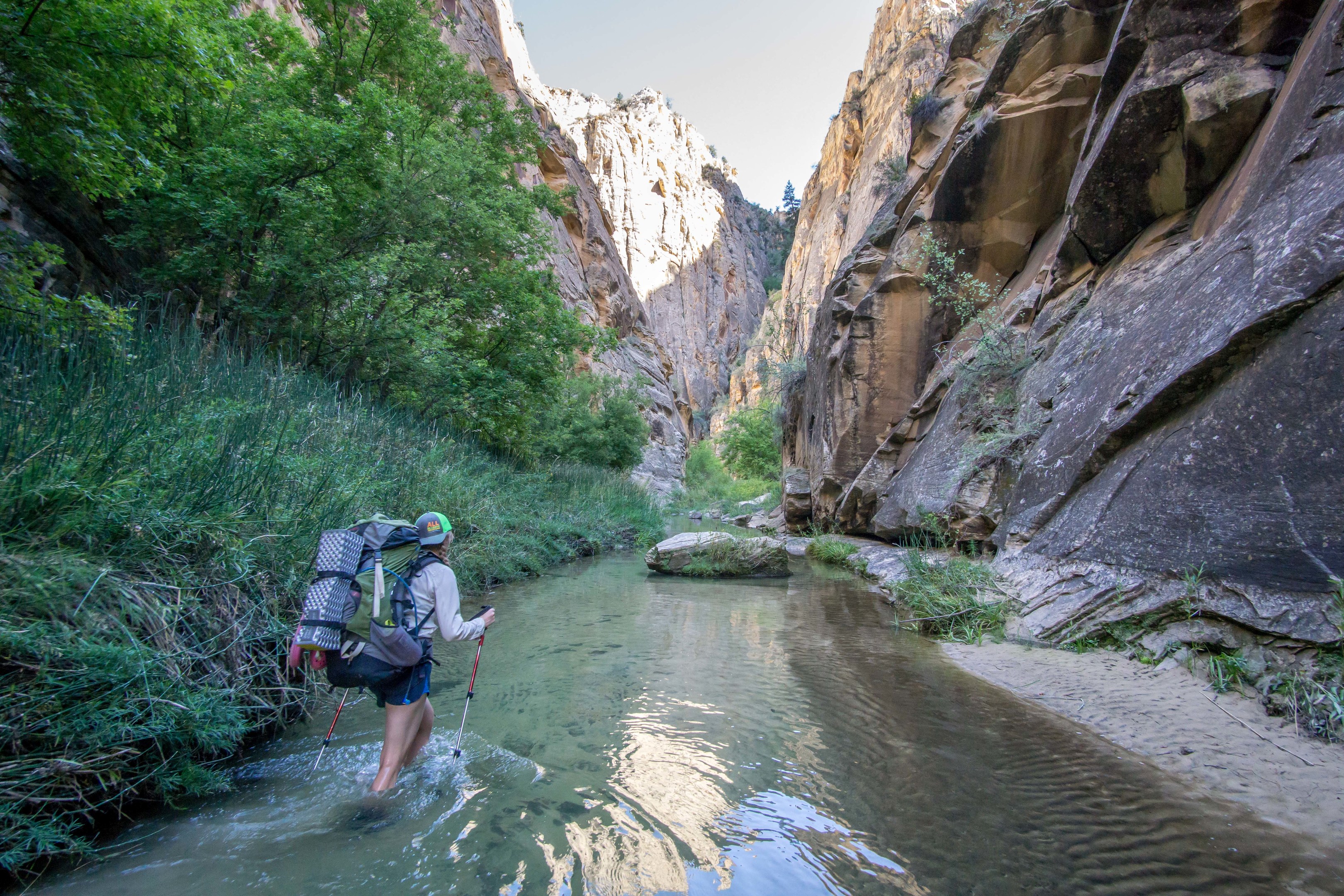
Once in Death Hollow, everything changes. From the intersection with the Boulder Mail Trail, Death Hollow runs about 9 miles to the confluence of the Escalante. This is the highlight of the trip and the primary reason for creating the loop. Backpack down Death Hollow and enjoy the absolutely stunning scenery. Massive white and red rock walls tower on each side, while the water in Death Hollow is crystal clear and cool. There are very few desert canyons that contain water so clear. This place is truly unique and special. To make this a three-day loop, it is important to hike almost all of Death Hollow on day two. To do this, you must pass through "the narrows," which contains a very difficult spot to pass. The rock walls tighten and the creek gets deep. There is a ledge that is possible to hike on, but not without consequence. It would be very easy to slip off this ledge into about 10 feet of water, which would absolutely soak a backpack and its contents. It is possible to use a rope to lower backpacks through this section, which makes hiking it much easier and less consequential should you slip.
Camp in one of the many beautiful beaches, and on day three, hike the Escalante River upstream back toward town. Make sure to stop in the big alcove to check out the Anasazi petroglyphs. Return to your car and bask in the desert warmth, for you have just completed a truly epic desert backpacking trip.
Backpacking the three-day loop described will satisfy the wilderness needs of every hiker, but it is not without its challenges. Death Hollow is remote, so do not expect help from any other hikers. Poison ivy is abundant in the canyon, so make sure you are able to identify the plant without walking into it. And as always, make sure the weather looks clear before going into Death Hollow. Camping in this canyon in high water would be a scary experience.


Comments
Five to six people (presumably 2-3 tents) is pretty big for a wilderness like Escalante. The trail may very well be able to handle more, so look for a second opinion if you want, but as a backpacker I'd better appreciate the place with a smaller group.
Sign In and share them.